Little Heights Flooding with Harvey
Minimal Heights Flooding with Harvey
The Heights is named that for a reason. The Heights was built on much higher ground than the low, swampy, mosquito-infested area around Allen’s Landing… the new city of Houston. If the Heights ever floods, it means downtown Houston would be 20-30 feet under water. Other than the usual low spots on White Oak Blvd., and areas to the west of the Heights, there was little Heights flooding with Harvey.
Now, no place remained dry during hurricane Harvey. The Heights, like everywhere else had localized street flooding. My son lives on Cortlandt St. and has photos of himself wading in over a foot of water. Curbed streets are designed to be water channels and they do fill up.
Some Heights flooding with Harvey did occur on the southern boundary where White Oak Blvd dips down, but few houses were affected. The streets all dip down, close to I-10 but the surrounding lots are on higher ground. White Oak Blvd and Houston Ave is a notorious low spot that always fills up with water. “Luckies” Pub sits in the middle of the lake that forms. There are also some condos built in low areas, but that is about the extent of the problem here.
See the flood plain map of Greater Heights below. It came from this Flood Mapping Tool that shows any location in Harris County.
Note: The blue indicates potential 100 year flood; dark blue is floodway (moving water); green is 500 year flood plain.

Flood Plain Map shows little expected Heights flooding with Harvey. The “Heights” is east of N Shepherd
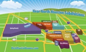
The boundaries of the Heights are generally described as being between 610 N Loop and I-10, and between N Shepherd and I-45. Most of this area is pretty high. Outside the Heights, West of Shepherd is Shady Acres and Timbergrove Manor. A lot of this is well within the flood plain and more affected.
The east boundary of the Heights is I-45. This was a rectangular lake after Harvey. I made the photo below from the overpass at Pecore St. If you look at the flood map above, it shows this section of 45 as light blue, meaning it is in 100 year flood plain. I-45 here will eventually be widened. I hope this flood puts an end to the talk of making this a tunnel. This tunnel would become an aquarium.

Most of the Heights was high and dry after Harvey but next to it I-45 filled up with water.
Flooding Near the Heights did Occur
Nearby Timbergrove Manor is outside of the Heights. It was hit hard in places and spared in others. After hearing that this was a 500 year flood, I installed an app called FloodMap on my phone and drove around Timbergrove and Lazybrook. This app shows the 100 year boundaries and your location within it. So I could drive toward the “deep” parts of the flood plain looking for signs of flooding.
I expected to find flooded homes outside the 100 year flood plain, but I didn’t. I was pleasantly surprised that lots of Timbergrove streets fairly deep within the 100 year boundaries were not affected by hurricane Harvey. No piles of sheetrock or telltale white curbs and streets where the sheetrock used to be.

A Timbergrove Manor street after hurricane Harvey. This was just off TC Jester.
Shady Acres (part of Greater Heights) is also in the flood plain, but is an area of mostly new construction. The streets may have filled with water, but the recent-construction homes are built above this, so not affected.